Showing posts with label Philly Area Hiking. Show all posts

Trip Report: The Batona Trail and Wharton State Forest in Pictures

Our 15-mile loop in Wharton State Forest.
I went backpacking in New Jersey this weekend. Believe it or not, the same state that brought us The Jersey Shore TV show is also home to beautiful forests, meandering streams and plenty of opportunities to explore them. This weekend's adventure took Dan and I to the Wharton State Forest and a portion of the Batona Trail.

The Batona Trail, short for (BAck TO NAture), is a flat, meandering 49.5 mile hiking path winding through three New Jersey state forests. It was built in 1961 by the Philadelphia-based Back To Nature Hiking Club. Club President Morris Bardock collaborated with the Department of Conservation and Economic Development to build a trail connecting Brendan T. Byrne (formerly Lebanon) and Wharton State Forests.(Visit Wikipedia and NJPineBarrens.com for more history.)

With only two of us in one car on this trip, we didn't hike the trail end to end as a shuttle trip, but came up with a low key 15 mile loop, pictured above left. Our itinerary also involved an overnight at the only primitive campsite without any other registered campers!

Dan and I started from Batsto after picking up a camping permit for Lower Forge. They're required if you want to spend the night in a state forest. For two of us, the permit cost a whopping, bank-breaking $4! The forest sees numerous boy scout troops and other groups during warmer months, and we were told we'd picked a great time to come. Batona Camp, our original destination, had over 40 registered campers while Lower Forge didn't have any.

Dan at the Batsto Batona Trail sign.

The Batona Trail and most of the trails in Wharton State Forest are flat and easy, which was part of the appeal for this weekend! If you're looking for spectacular vistas and elevation change, this area isn't for you. But my goal was to drive less than an hour and spend the weekend walking around a beautiful place I'd never explored before. I wanted to stretch my legs, warm up for backpacking season, and just get out there!

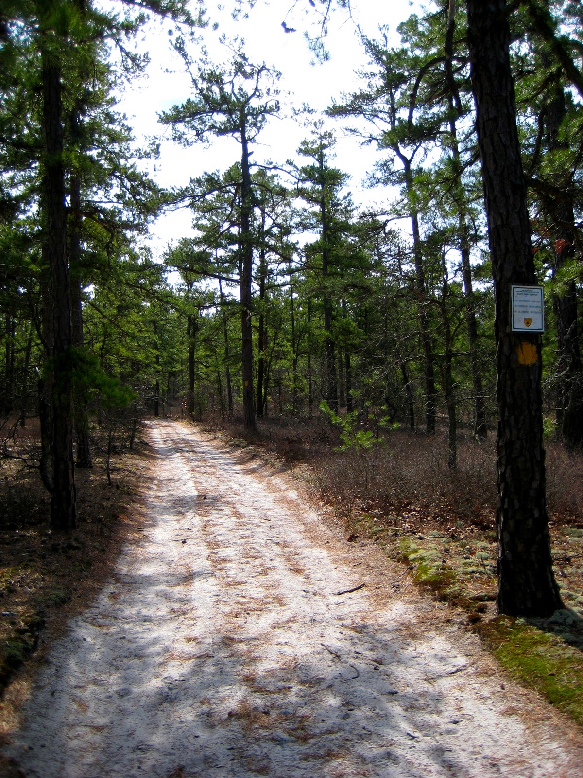
Most of our hike looked like this!

The Pinelands are a pretty amazing place in general, another reason for our choice of trail this weekend. The area is nicknamed the Pine Barrens because of the barren soil; crops were difficult to grow there. The soil is so full of minerals, particularly iron ore, that some of the water appears rust colored. Though some will tell you the rivers run red with the blood of the Jersey Devil's victims! We escaped unscathed, thank goodness.

Red water near Quaker Bridge on the Batona Trail. (D. Herscovitch)

We reached Quaker Bridge around lunch time. I knew the trail would be flat and the scenery wouldn't change much, but it was still great to have a break from the sand and pine trees! We stopped for a snack, then continued on to Lower Forge Camp.

Happy after a snack at Quaker Bridge! (D. Herscovitch)

We arrived at Lower Forge after crisscrossing dirt roads and found the connector trail to Lower Forge Camp. Thankfully, no motor vehicles are allowed within 1/4 mile of camp. A group of boy scouts had stopped for lunch, but after they moved on, we had the entire giant site to ourselves! We'd talked about dropping our packs and hiking up to Batona Camp (six miles away) for fun, but we'd both tired of the flat trail and spent the afternoon relaxing at camp. One of my favorite things in the world is taking the tent out on my first trip of the season!

Evening descends on our camp at Lower Forge.

Dan got a great fire going after he took care to rake pine needles and other debris from around our little fire pit. The Pinelands are particularly susceptible to forest fires, and taking caution is important. We brought along some of my favorite backpacking foods, including a few Kielbasa sausages. Extra time at camp meant extra time to eat!


Dan's hands-free sausage roasting setup. Ingenious!

Thanks to REI's blog, we knew we were in for a treat that night - the largest full moon in 20 years! But I fell asleep long before the moon rose high enough for photos, and snapped this one of the Batsto River, which looked more like a swamp, at dusk.

Sun sets on the Batsto River.

We set out the next morning back down the Batona Trail from Lower Forge to Quaker Bridge. After crossing Quaker Bridge, we picked up a green blazed connector trail. Dan and I both decided green blazes should be prohibited on hiking trails in forests. And if they're allowed, they should be a different shade of green than the forest! As the trail wound through the woods, we came to an area with an above average collection of living underbrush. Most of the area was devoid of small plants and shrubs. It looked like the forest had burned and was beginning to recover.

Dan moving into a burned section of forest.

The green blazed connector trail led us to the Mullica River Trail, which would take us back to Batsto Village and our car. The yellow blazes were definitely easier to see than green!

Presenting... a brand new looking trail sign!

Most of the Mullica River Trail looked like the shot below...wide and a little boring! It was nice to walk side by side along the river, though. Normally, you'll spend miles just staring at the heels of your hiking companions! The highlight was passing Mullica River Camp and the canoe/kayak launches. The trail crosses over roads used by Jeep clubs and off road vehicles, and we ran into a long line of Jeeps not far from Batsto.

The very wide and flat Mullica River Trail.
We finally made it back to Batsto mid afternoon. The Historic Village is a neat place, and I'd highly recommend making it part of any Wharton State Forest trip. All in all, the trip was exactly what I expected. The trail was flat with little change in scenery, and I'm not sure I'd go back for another trip unless it was to hike the Batona Trail end to end!


Batsto Historic Village

What are some of your favorite easy, low key backpacking trips? Have you been on the Batona Trail? Tell me in the comments!

Playing on Ice - Ringing in 2011 at Ricketts Glen

Our crew on New Year's Day - Bill, Brian, Aleya, Dan, Patrick and Me.
I can't remember how I spent the first day of 2010. And no, it's not because I was that hungover. According to my Google calendar, I went skiing. Did I go skiing? Hm... The first day of 2011 was a different story, and after a day on icy trails in Northeast Pennsylvania, I have a feeling I'll remember this one next year.

After spending New Year's Eve with friends and a beautiful concoction of warmed gin and Madeira, I went to sleep with my alarm set for 7am. I hit snooze at least twice, realized our 7:30am departure deadline was looming, and rolled out of bed both cursing and admiring those who have a knack for real alpine starts.

Our plan was to welcome 2011 with open arms - arms holding ice tools. Patrick organized a small group hike, complete with ice route scouting, in Ricketts Glen State Park. My first cold weather trip there was on Valentine’s Day last year for a guided ice climbing trip. I never imagined I’d be back with friends hoping to climb on our own, and capable of doing so.

the trail, completely covered in ice!
Ricketts Glen is notoriously icy during the winter. Parts of the trail, which winds through a series of waterfalls, are completely covered in feet of it. Warning signs at the trailheads tell visitors that the park is closed during the winter to all except registered ice climbers and experienced, properly equipped hikers.

We took the Falls Trail from the Rt. 118 parking lot up through Kitchen Creek without incident, passing three waterfalls (Murray Reynolds, 16’, Sheldon Reynolds, 36’, and Harrison Wright, 27’) before breaking at Waters Meet. Continuing up the west branch of the Falls Trail, we encountered exactly what we’d come for - a whole lot of ice. Each of us came prepared with crampons and ice axes, though we’d passed a handful of folks on the trail who seemed ill prepared. Climbing and traversing thick sheets of ice, I marveled both at the formations themselves and how vulnerable walking on them made me feel.

Before reaching Ganoga Glen and the park’s tallest waterfall, one of the couples we’d seen earlier passed us heading back down the trail. The man looked as though he’d fallen, face bloodied and scratched, completely soaked, but otherwise alright. They’d tried to traverse the icy parts of the trail without proper gear, and considering what the outcome could have been, he was lucky. After offering help, we all moved on.

Patrick scouting ice next to Ganoga (94').
We’d hoped to find climbable ice near Ganoga (94’). Unfortunately, several days of warm temperatures left the falls exposed and the area generally unstable, albeit breathtakingly beautiful. We crossed the creek to scout the east edge where huge pillars form from runoff and spray. I had an uneasy feeling about trying to climb there; everything seemed to be falling apart. But I get that uneasy feeling a lot – it’s fear – and I pushed it away. After some in the group suited up and Patrick went to see about setting up ropes, we heard a giant crash as one of the pillars out of sight above us collapsed. Blocks of ice, one the size of a washing machine, tumbled down near where we stood, adding to a pile another hiker warned us was the result of a pillar collapsing shortly before we arrived.

We took the hint and packed up, retracing our steps back to Rt. 118. I was glad to see some hikers with Yaktrax, and others who’d turned around after reaching particularly icy spots. I couldn’t imagine trying to hike as far as we did without crampons. Of course, as soon as we took the crampons off and reached the flattest part of the trail, I managed to slip on a small sheet of ice and slide partway down the trail in front of a family with two toddlers. The kids thought it looked like and went to do the same thing. If their mother is reading this, I apologize!

All in all it was a perfect day. Though we didn't get any ice climbing in, we saw some incredible ice formations, stayed safe, and spent the first day of 2011 with wonderful friends. But it was also a reminder to be prepared and pay attention to your surroundings. What are some of your winter hiking tips?

Top Five Philadelphia-Area Fall Foliage Day Hikes

Even though autumn is technically still two weeks away, it one of my favorite times of year here on the east coast. The smell of the leaves, the spectrum of colors, and the impending arrival of winter! I'm hoping I can get it to come faster by writing about some of my favorite places around Philly to take in the fall colors on the trails. Each of these hikes are fun to do regardless of the season, but are particularly beautiful in autumn, and all are 100 miles or less from the city. They're in no particular order. Enjoy, and leave your fall foliage experiences in the comments section! 

The Pinnacle/Pulpit Rock
Photo by Paul H., Oct 2009.
The moderately strenuous Pinnacle/Pulpit hike provides some of the area's most beautiful vistas. No matter the season, the trail will be enjoyable!

From the Hamburg Reservoir parking lot, follow a gravel path to the white blazed Appalachian Trail. The trail meanders up to Pulpit Rock, then flattens and continues on for another two miles to the Pinnacle. A giant cairn marks the Pinnacle, and the nearby cliffs offer incredible views of the valley below. Backtrack from the vista to the cairn, keep right, and follow an abandoned road to descend. Finding the descent trail can be the trickiest part. The blue blazed trail passes a grassy area and turns left into the woods. At the intersection with the AT, turn right to retrace your steps back to the parking lot.

Trail Length and Time: Loop hike, 8 miles, 5-6 hours
Distance from Center City Philadelphia: 1 hour 25 mins, 80 miles
Maps: the best I've found are on trails.com.
More Information: general Appalachian Trail information 

Hawk Mountain Sanctuary
Autumn leaves, Nov 2008.
Right near the Pinnacle/Pulpit, Hawk Mountain is a perfect place for foliage and bird watching. Trails wind through woods, around literal rivers of rocks, and up the mountain itself to spectacular views of the Lehigh Valley.

There are eight miles of trail options with some following paved areas and wide, sandy paths and others requiring hand-over-hand scrambling. If you arrive to find the parking lot full, don't despair; the majority of visitors stick to the easily accessible trails!


My favorite loop combines a walk through the woods with the River of Rocks and the North Lookout. From the parking lot, follow the wide partially paved path to the sanctuary entrance, follow the trail up and turn right on to the red blazed River of Rocks trail. The trail can be difficult to keep track of; make sure to keep looking for blazes. After looping around the entire River of Rocks, ascend to the Skyline Trail via the Golden Eagle connector trail. This is where the real fun starts! The blue blazed Skyline trail is, in most places, a pile of boulders. Be careful here and take your time. I'd suggest changing plans if it's been raining; the rocks are slippery when wet. Continue along the ridge following blue blazes, and one final short, steep hand-over-hand section will bring you to the lookout. You'll likely find a crowd at the top, but remember, you took the fun way up! Descend via the Lookout Trail (yellow blazes) back to the visitors center. 

Trail Length and Time: suggested loop hike is 6 miles, 4-5 hours 
Distance from Center City Philadelphia: 1 hour 35 mins, 90 miles 
Maps: Hawk Mountain provides this map online and a printed one at the visitors center. 
More Information: The Hawk Mountain website has plenty of information for you before you go, and I definitely suggest looking through it. Take sturdy shoes for this one and be aware of the entrance fee, which helps the Sanctuary continue to operate. It's a bit higher in the fall ($7 instead of the normal $5). 

Delaware Water Gap National Recreation Area - Mount Tammany
Photo by Carl Ewald, Oct 2008
Located on the New Jersey side of the Delaware Water Gap, it's a perfect short day hike for beautiful views of the Delaware River. It's also a popular one with numerous other trails in the area, including the Appalachian Trail.

Take the steep Red Dot (Tammany) Trail to the summit from the Dunnfield Parking Area, and enjoy views of Mt. Minsi across the Delaware. Lucky hikers might have the chance to see trains moving along the river below, and it's a perfect place for a lunch break. The Red and Blue Dot trails meet just past the top, and the Blue Dot Trail is best for the descent. It's much easier on the knees than completing the loop in the opposite direction. The Blue Dot Trail ends at beautiful Dunnfield Creek and joins the AT back to the parking lot. 

Trail Length and Time: Loop hike, 3 miles, 2-3 hours round trip
Distance from Center City Philadelphia: 1 hour 45 mins, 100 miles
Maps: National Park Service area map and brochure
More Information: NPS Delaware Water Gap NRA website

Delaware Water Gap National Recreation Area - Mount Minsi
Changing leaves, Sept 2009.
Right across the Delaware River from Mt. Tammany, the Appalachian Trail passes through the town of Delaware Water Gap, PA and over the top of Mt. Minsi. Less popular than Mt. Tammany, but equally beautiful in autumn, it's a more leisurely way to get your fill of Water Gap fall foliage. If rock climbing is more appealing to you, there's plenty of that as well.

My preferred route follows the white blazed AT from the Lake Lenape parking lot. The trail crosses a wooden bridge and meanders through the woods at first, then ascends gently. Cross the wide Mt. Minsi fire road and continue to follow the AT to what's left of a fire tower, which marks the top.  You can also shorten the hike here if need be by turning on to the fire road before summitting. Backtrack to the fire road and follow it back down to the parking lot to complete the loop.

Trail Length and Time: Loop hike, 4 miles, 2-3 hours round trip
Distance from Center City Philadelphia: 1 hour 45 mins, 100 miles
Maps: National Park Service area map and brochure
More Information: NPS Delaware Water Gap NRA website

The Wissahickon Gorge
Livesy Rock area, Sept 2009.
The Wissahickon is, in my humble opinion, the best part of Philadelphia's Fairmount Park and one of my favorite things about the city itself. Encompassing 1,400 acres of steep ravines and beautiful scenery, it's easy to forget the park is within the limits of our country's sixth largest city. When autumn comes, all of the gorge's deciduous trees turn shades of yellow, orange and red, dropping leaves into the Wissahickon Creek.

Forbidden Drive, more of a gravel road than a trail, runs for just  over five miles along the edge of the creek from the beautiful Valley Green in to a small parking lot on Lincoln Drive. But hikers could spend all day wandering around in the park taking in the autumn leaves. I'd recommend purchasing a map to help guide you through the more than 50 miles of trails.

Trail Length and Time: as long or as short as you'd like it to be!
Distance from Center City Philadelphia: 10-15 miles
Maps: Friends of the Wissahickon puts out the best map I've found, available here

    Conestoga Trail Hike

    the mighty Susquehanna River
    One of the most challenging parts about training to climb Mount Rainier is finding training hikes close to home that incorporate the kind of elevation change I need to be prepared for; forget the actual elevation! With our schedule for the Summit for Someone climb, we'll gain 5,000' the first day, and the remaining 4,400' or so to the summit the second day. The highest point in PA is Mount Davis at only 3,215'! There are certainly some challenging hikes with a lot of hills within a few hours' of Philadelphia, though, and we found a doozy this weekend.
    I had the pleasure of venturing out on to part of the Conestoga Trail with the Wilmington Trail Club this Saturday. The trail runs north-south for 63 miles in a beautiful section of south-central PA. I didn't know the trail existed until friend Alec forwarded the WTC's list of spring hikes, and suggested I choose one to do with him. I learned after that the WTC typically hikes 10-20 miles on one weekend day, depending on the hike leader.

    We left several cars at the Pequea Creek Campground, which would be the end of the hike, and drove to a nearby park in Holtwood to start the day. The beginning of the hike was deceptively flat, then sharply turned downhill as we wound along the Susquehanna River. Of course, if you descend from where you started, it eventually means going back up! I stopped counting the hills after number three, and tried my best to push the burning sensation in my legs out of my consciousness. I was impressed with how quickly the group moved and did my best to keep up with my 30 pound pack on. I was pouring sweat by the end of each steep incline, and grateful when we stopped for lunch along beautiful Kelly's Run.

    The second half of the day was by far the most rewarding. We were treated to some incredible views of the Susquehanna River. The neatest part was what group leader Jim March called Wind Cave. When I heard the word "cave," I envisioned something I'd boulder in - not deep, something you could sit in, maybe fit a tent in. On the contrary, it's a relatively narrow, but incredibly deep crack in the beautiful rocky hills (pictured right). One group member mentioned it ran all the way down under the river! With cool air pouring out of it, it was a perfect place to stop and take another midday break and do a little exploring. I didn't go in far, but far enough to satisfy my curiosity.

    By the time we made it back to the Pequea Creek Campground where we'd left the cars, we'd covered just over 11 miles and climbed 2,400'. It certainly satisfied my hike requirements for the weekend. Alec and I devoured apple pie and a chocolate peanut butter sundae, respectively, after the hike - a day's work well done!


    Lesson Learned - Hoagies are Bad for Hiking
    I definitely made a mistake during the hike that had a big affect on how I was feeling, and I should know better. I ate a big roast beef hoagie on white bread for lunch, and felt my energy level take a nose-dive. I felt sluggish and a little dizzy, despite staying hydrated. I don't typically eat giant sandwiches full of meat on white bread, and have no idea why I thought it was a good idea to do it on a day when I needed good clean fuel.

    One of the best pieces of advice I got for extended trips is to create meals and snacks out of things you normally eat, are good for you, and like. If you don't like almonds, even if they're the best hiking snack in the world, don't take them with you. You won't eat them, or you'll eat them and hate it. If you rarely eat meat, but bring a giant stick of pepperoni backpacking with you because you heard it's good to nosh on, you're going to have an uncomfortable few days.

    I'm not a fan of white bread. I don't eat it often, and know what it does to my energy level. I also don't eat red meat very often. But white bread hoagies were all they had at the grocery store the morning of the hike, so I ate one, and paid the consequences. I definitely could have avoided that problem with better preparation. Lesson learned, and on to the next adventure!

    TerraMar Trip Report: Hiking and Pie!

    TerraMar's first Hike and Pie event of the season took place Saturday, and it's a particularly fun event to lead. I've discovered our members are much more enthusiastic about getting through the toughest parts of a hike when there are four freshly baked pies waiting for them at the bottom! It was great to be out in the Delaware Water Gap for the first time this spring. I really enjoy seeing a place as it changes throughout the course of the seasons.

    Mount Tammany, despite being a short hike, is one of my favorites in that area. The trail doesn't afford you much time to warm up; it begins climbing steeply right from the parking lot. But the further up you go, the more rewarding the view is. Each of the three viewpoints on the ascent provides a more spectacular view of the Delaware River. Even though you're quite close to I-80, you'd hardly know it. The higher you go, the more the sounds of rushing cars falls away.

    One of my good friends, Lauren, came along on the hike to learn about being a TerraMar guide. She and another super strong #badassgirl, Carla, are the newest proposed additions to the TerraMar team. On the ascent, Lauren mentioned how methodical my steps were, and how purposeful. It got me thinking, of course, about life in general, and how I approach journeys from one destination to another.

    I think a lot. I analyze things a lot. I like to be deliberate with my movements and my decision, each being carefully and critically thought through. I'll do my best to make sure I've got as much information as possible to avoid uncertainty, and if I haven't done that work, the event/day/hike/etc. becomes more stressful. I'll likely look for someone else to make a decision about that event.

    I've done the Mount Tammany hike at least half a dozen times, but still felt better looking at the map Carla printed out to verify the colors of the blazes we were following. Verifying what I already knew was comforting. Dan and I planned to camp near Ralph Stover that night, and try to find our way to the crag the next morning without a guide book or help from people who'd been there before. But the thought of not knowing where the crag was or anything about where specific routes were really ate away at my climbing motivation. The fact that the temperature dropped to the low 30's at night and topped out at 45º the next day certainly didn't help! We ended up finding the campground, but when we woke up the next morning, we decided to explore a little town in the area, then head to PRG Oaks for indoor bouldering instead.

    I know that uncertainty is part of life, and that I'll never evolve in climbing, or in anything I do if I let that uncertainty get to me. I'm learning to tell myself that it's alright if things don't go exactly as planned - it doesn't mean the plans were a failure, it's just life's way of teaching me to be more flexible. And it means I'll know more about how to plan next time. Part of my personal evolution is becoming aware of how I react to situations, why, and what I can do to manage those reactions. It's an ongoing process, without a doubt!

    TerraMar Trip Report: Pinnacle Winter Hike

    It was a perfect, beautiful Sunday for a hike to the Pinnacle, touted as one of Pennsylvania's greatest vistas. AT thru-hikers have remarked it's one of the prettiest views in the state, and I'm beginning to agree with them! We did the hike as a group this past August, but visibility was so awful from a thunderstorm rolling in that we didn't get to see more then three feet in front of us when we got to the vista. I told other TerraMar guide on the hike with me that I didn't believe there was any vista at all! But I was definitely proven wrong this time.

    We left Philadelphia at 7:30am and were out on the trail by 10 in a group of 16. It was in the mid-30s in the morning and snowing, but midday the snow let up and the sun came out. We all had trouble finding room for extra layers in our backpacks when it warmed up. I was comfortable hiking in a base layer with my rain coat and rain pants on, despite having brought my down jacket and assuming I'd need it.

    The trail begins with a gentle incline, then rises sharply a mile in. After another mile and a half of climbing, we reached Pulpit Rock, pictured at the left. It was beautiful, and also marked the end of the really hard part of the hike! The trail was pretty well packed down up to that point with obvious steps up to Pulpit Rock. No one wore crampons or used trekking poles, and we rarely punched through the snow. It was great! Pulpit Rock is a turnaround point for some hikers, and others proceed another mile toward the Pinnacle and bail out on a red-blazed trail. The trail between Pulpit Rock and the Pinnacle wasn't as well stomped down, but we still had no trouble navigating.


    We reached the Pinnacle just after 1pm, pictured right, and the view was certainly worth the trip! It dispelled any doubts I had about its existence. The snow still fell a bit, but the sun was weaving in and out of the clouds, casting shadows on the hills around us and the landscape below. It was beautiful. We stopped for a snack break and photos, then proceeded down an abandoned fire road back to the parking lot. We met a group of snowmobilers on the way, and I was thankful they'd packed down the snow for us!

    We arrived back at the cars just after 2pm, which is the fastest I've ever hiked that trail with TerraMar. A group of us were anxious to make it back home to watch the Canada vs. US Olympic gold medal hockey game. I walked in the door just as the second period started, and spent the afternoon watching the game while Dan, who's Canadian, bantered back and forth with American friends on the phone.

    It was a perfect day for a hike, and a great, enthusiastic group of TerraMar folks. We're doing the Pinnacle/Pulpit hike again in April, but the next hike we've got coming up is one of my all-time favorites - Mount Tammany Hike and Pie!

    Trip Report: Delaware Water Gap Backpacking

    I'm from upstate New York, lived in Alaska, and as a result, I've developed a general distaste for heat. I'm much more comfortable when it's chilly, and generally avoid any climate or activity that results in significant sweating if I can help it. Nevertheless, I spent this past weekend in unbearable heat and humidity backpacking around the Delaware Water Gap area of New Jersey.
     

    A friend is training to hike the Grand Canyon rim-to-rim in a month, and asked if I'd accompany him and his dog on a high-mileage weekend. We kicked around a few options, and finally settled on combining day hikes we'd both done in the DWG. The initial thought was to climb Mt. Minsi on the PA side of the DWG, head back to the car, and drive a few miles into NJ to hike more and find a campsite. I would do Mt. Minsi without a pack, as I'm not training for anything, then put the pack on in NJ.

    As it turned out, we opted to spend all of Saturday hiking in NJ, both with our packs. I jokingly told Josh I didn't want people we passed on the trail to think he was carrying all the gear while I just had a Camelback on! We started with a climb up Mt. Tammany, which requires a 1250' ascent in 1.5 miles. I definitel
    y wouldn't recommend doing anything like that to start. Our muscles weren't warmed up, it was 90º and humid, and we were both exhausted after the ascent.

    We descended down the back of Mt. Tammany and picked up the AT to Sunfish Pond, a beautiful little glacial oasis. It's quite acidic and can only support a few hearty species of fish and frogs. The hike to Sunfish Pond is 8 miles round-trip. By the time we arrived at our chosen off-trail campside, we w
    ere both very much ready to call it a day. We'd made it just over 11 miles. I'd been snacking on trail food all day, (trail mix, mini-Clif bars, cereal), and couldn't manage to find the energy to eat the rice and tuna I'd brought. The heat and humidity had sapped all of our energy.

    After waking Sunday morning, we opted to hike the three miles out to the parking lot and head home. But not without a stop for
    pie and fresh local vegetables on the PA side! It was my first night in my new Big Agnes Emerald Mountain 3 tent, which is much too large for one person, but should be perfect for two with room. It was a cinch to set up, and looks pretty good in the woods (see right).


    I was quite worried about dehydration and heat exhaustion the whole trip. I have an MSR Miniworks EX Microfilter (see left), and pumped water as frequently as I could into my 1.5L Camelback reservoir, but I couldn't seem to drink fast enough. There's always a danger of over-hydration as well. But it takes time for your body to get used to expending significant energy in an extremely hot environment, and we probably overdid it a bit the first day. I was a little dizzy at points, which is never a good sign. Lesson learned, though, and I'll take it a bit easier next time

    TerraMar Trip Report: Pinnacle Hike, Thuderstorm Safety

    taking in the "spectacular views" from the Pinnacle in the rain!

    Yesterday marked yet another successful hike with TerraMar Adventures. The weather was dismal when I rolled out of bed, the result of a giant rainstorm moving across PA. I jumped in the car and drove to the Hamburg Reservoir parking area to meet the four other adventurers who'd agreed to brave the weather with us. Luckily, by the time we reached the reservoir, the rain had stopped. The weather forecast included additional showers and thunderstorms during the day, but we moved ahead with our plans anyway. After a small handful of wild raspberries, we took off.

    The Pinnacle/Pulpit route mostly follows the white-blazed Appalachian Trail, depending on which route you take. We followed the trail indicated in yellow on the map to the AT, and branched off toward the Pulpit. The trail is quite wide all the way up, and we were able to walk side by side for most of the trip. Near the Pulpit, the trail gets rocky and can be slippery in the rain. The view from the Pulpit is supposed to be breathtaking, but our view was more than obscured by the low-lying clouds. I'm hoping to get back sometime when the weather is better!
    though hazy, the views were still great.
       
    We continued on to the Pinnacle, at which point the rain began to fall and we heard the distant rumble of thunder. We immediately started back down the trail along the AT toward the helipad area on the map. This route kept us further in the woods and out of exposed areas along the ridge. We reached the helipad and branched off to the left, heading south toward the Hamburg Reservoir. By the time we reached the reservoir, we were shedding rain gear and layers as the sun peeked through the clouds and the thunder stopped. 

    The end of the day turned out perfectly, and after nearly nine miles of trail, we were ready for food. Our little caravan made it to CJ Hummel's restuarant in Lenhartsville, where I had one of the best restaurant-made grilled cheese sandwiches I've ever had! Try it Philly cheesesteak style - cheddar, onions, mushrooms and sweet peppers - on whole wheat bread.

    The day was great overall. Leading group hikes with people you've never met can be tricky, especially when the weather turns sour. But our group was fantastic, very positive and upbeat the entire day. Of course, things could have taken a terrible turn had the thunderstorm been closer to us. We should have considered changing our plans, but being as excited as we were about the day on the trail, we did not. I'm sure many of us have found ourselves in a thunderstorm while engaging in outdoor pursuits, and I wanted to share a little information with you about how to manage thunderstorm risk.

    Safety Tips for Hiking in a Thunderstorm
    Information here and here from the Red Cross

    The two most dangerous places to be in a thunderstorm are in open spaces and under trees, which is where hikers normally are! Of course, the best thing to do is not to get stuck in the storm in the first place. Change your plans to avoid the storm, and minimize risk as much as possible. If you do find yourself in a storm without shelter nearby, keep the following in mind:
    • Plan your hike around the weather. If you know a storm is coming, keep in mind they typically develop mid-afternoon in the summer. 
    • If you're outdoors away from vehicles and other shelters, find a low area with short trees or shrubs. 
    • Avoid tall or isolated trees, utility poles and fences, and areas that are obvious draining or runoff areas. 
    • When you find a spot, crouch low to the ground on the balls of your feet. Do not lay down. 
    • Do not take shelter under overhanging rocks. They can be targets for lightening. 
    • If you're camping, make sure your tent is not the tallest object in the vicinity. 
    • Don't camp on a hill, under isolated trees, or near any metal objects.