Showing posts with label Hiking. Show all posts

Sharing the Adventure-Inspired Love with Pemba Serves and Section Hiker!

I've been a lucky girl the past week and a half. Well, all the time, but especially this past week and a half! I had the opportunity to share thoughts this Wednesday and last Thursday about two of my favorite topics outside of the Adventure-Inspired forum, those two topics being Big City Mountaineers and rock climbing.

The Beautiful, Winding Road to the Top of Mount Rainier with Big City Mountaineers
There's no quicker way to bring a smile to my face than to broach the Big City Mountaineers and Summit for Someone topics. The organization is has done and continues to do incredible things for urban teenagers by giving them the opportunity to have transformative outdoor experiences. In this guest post for Pemba Serves, learn what my Summit for Someone climb of Mount Rainier in August of 2010 was like from start to finish!

What Rock Climbing Can Do For You
If you read Adventure-Inspired regularly, you know how much I love climbing. Hiking and backpacking are among my other favorite activities, and I'm an avid reader of Philip Werner's Section Hiker blog. Philip took off on a long walk along the Appalachian Trail this month and asked if I'd be willing to write about a topic not often mentioned on Section Hiker - rock climbing! Read more about what I've gained from the sport and why everyone we know should try it.

Keep your eye on both of these forums if you don't already. They're great sources of information! And a huge thanks to both for giving me another soapbox to stand on and talk from!

Trip Report: The Batona Trail and Wharton State Forest in Pictures

Our 15-mile loop in Wharton State Forest.
I went backpacking in New Jersey this weekend. Believe it or not, the same state that brought us The Jersey Shore TV show is also home to beautiful forests, meandering streams and plenty of opportunities to explore them. This weekend's adventure took Dan and I to the Wharton State Forest and a portion of the Batona Trail.

The Batona Trail, short for (BAck TO NAture), is a flat, meandering 49.5 mile hiking path winding through three New Jersey state forests. It was built in 1961 by the Philadelphia-based Back To Nature Hiking Club. Club President Morris Bardock collaborated with the Department of Conservation and Economic Development to build a trail connecting Brendan T. Byrne (formerly Lebanon) and Wharton State Forests.(Visit Wikipedia and NJPineBarrens.com for more history.)

With only two of us in one car on this trip, we didn't hike the trail end to end as a shuttle trip, but came up with a low key 15 mile loop, pictured above left. Our itinerary also involved an overnight at the only primitive campsite without any other registered campers!

Dan and I started from Batsto after picking up a camping permit for Lower Forge. They're required if you want to spend the night in a state forest. For two of us, the permit cost a whopping, bank-breaking $4! The forest sees numerous boy scout troops and other groups during warmer months, and we were told we'd picked a great time to come. Batona Camp, our original destination, had over 40 registered campers while Lower Forge didn't have any.

Dan at the Batsto Batona Trail sign.

The Batona Trail and most of the trails in Wharton State Forest are flat and easy, which was part of the appeal for this weekend! If you're looking for spectacular vistas and elevation change, this area isn't for you. But my goal was to drive less than an hour and spend the weekend walking around a beautiful place I'd never explored before. I wanted to stretch my legs, warm up for backpacking season, and just get out there!

Most of our hike looked like this!

The Pinelands are a pretty amazing place in general, another reason for our choice of trail this weekend. The area is nicknamed the Pine Barrens because of the barren soil; crops were difficult to grow there. The soil is so full of minerals, particularly iron ore, that some of the water appears rust colored. Though some will tell you the rivers run red with the blood of the Jersey Devil's victims! We escaped unscathed, thank goodness.

Red water near Quaker Bridge on the Batona Trail. (D. Herscovitch)

We reached Quaker Bridge around lunch time. I knew the trail would be flat and the scenery wouldn't change much, but it was still great to have a break from the sand and pine trees! We stopped for a snack, then continued on to Lower Forge Camp.

Happy after a snack at Quaker Bridge! (D. Herscovitch)

We arrived at Lower Forge after crisscrossing dirt roads and found the connector trail to Lower Forge Camp. Thankfully, no motor vehicles are allowed within 1/4 mile of camp. A group of boy scouts had stopped for lunch, but after they moved on, we had the entire giant site to ourselves! We'd talked about dropping our packs and hiking up to Batona Camp (six miles away) for fun, but we'd both tired of the flat trail and spent the afternoon relaxing at camp. One of my favorite things in the world is taking the tent out on my first trip of the season!

Evening descends on our camp at Lower Forge.

Dan got a great fire going after he took care to rake pine needles and other debris from around our little fire pit. The Pinelands are particularly susceptible to forest fires, and taking caution is important. We brought along some of my favorite backpacking foods, including a few Kielbasa sausages. Extra time at camp meant extra time to eat!


Dan's hands-free sausage roasting setup. Ingenious!

Thanks to REI's blog, we knew we were in for a treat that night - the largest full moon in 20 years! But I fell asleep long before the moon rose high enough for photos, and snapped this one of the Batsto River, which looked more like a swamp, at dusk.

Sun sets on the Batsto River.

We set out the next morning back down the Batona Trail from Lower Forge to Quaker Bridge. After crossing Quaker Bridge, we picked up a green blazed connector trail. Dan and I both decided green blazes should be prohibited on hiking trails in forests. And if they're allowed, they should be a different shade of green than the forest! As the trail wound through the woods, we came to an area with an above average collection of living underbrush. Most of the area was devoid of small plants and shrubs. It looked like the forest had burned and was beginning to recover.

Dan moving into a burned section of forest.

The green blazed connector trail led us to the Mullica River Trail, which would take us back to Batsto Village and our car. The yellow blazes were definitely easier to see than green!

Presenting... a brand new looking trail sign!

Most of the Mullica River Trail looked like the shot below...wide and a little boring! It was nice to walk side by side along the river, though. Normally, you'll spend miles just staring at the heels of your hiking companions! The highlight was passing Mullica River Camp and the canoe/kayak launches. The trail crosses over roads used by Jeep clubs and off road vehicles, and we ran into a long line of Jeeps not far from Batsto.

The very wide and flat Mullica River Trail.
We finally made it back to Batsto mid afternoon. The Historic Village is a neat place, and I'd highly recommend making it part of any Wharton State Forest trip. All in all, the trip was exactly what I expected. The trail was flat with little change in scenery, and I'm not sure I'd go back for another trip unless it was to hike the Batona Trail end to end!


Batsto Historic Village

What are some of your favorite easy, low key backpacking trips? Have you been on the Batona Trail? Tell me in the comments!

Four Ways to Have Awesome Winter Weekend in the Adirondacks

The Adirondack mountains hold a special place in my heart. Aside from being beautiful and close, I've had many a great adventure there. Until the past year or two, most of my adventures in the High Peaks region had been in warm weather. But there's so much to do in the winter, and so much fun to be had! After a trip up to Keene Valley and Lake Placid this past weekend, I decided I had to do the region's cold weather possibilities justice on the blog! Here are my four favorite ways to guarantee an awesome winter weekend in the High Peaks.

Climb Some Ice!
George showing us how it's done with one tool*
This past weekend, friend and ice leader extraordinaire George took me and a group of friends out to Chapel Pond Canyon in Keene Valley. Our first stop was the Mountaineer to rent gear, including an older version of the Camp Cassin C Comp mono point crampons for me and ice tools for George - the Grivel Quantum Tech and Matrix Tech. (For the record, the tools and crampons were amazing, though I'm not convinced I'm experienced enough to pass judgment on mono vs. dual point crampons!) We parked at Chapel Pond and started the approach, which took us around the edge of the pond through knee deep snow and into the sparsely forested canyon. Our destination was Positive Reinforcement, a beautiful NEI 3+/4- flow that can, as we discovered, accommodate three parties and four ropes.

George led right up the center of the formation and set up two top ropes for us to work on throughout the day. The first climb, set up on the far right side of the flow, was the easier of the two with plenty of stemming and resting opportunities. The second, set right in the middle, took us over a more sustained vertical section. I had to feebly yell "take!" to my belayer near the top of the second climb as the predictable pump and panic set in. Some day, I'll be able to climb 90' of ice without panicking! Two other pairs of climbers came in and set up in between us. Watching one party forgo ATCs for hip belays and Munter hitch knots made for some interesting conversations.

*a note on the photo - I bet George a beer that he couldn't climb the whole pitch with one tool. I upped the ante to a six pack if he could do it without falling. He fell once. Only one beer for George!

Ski Some...Ice?

A cloudy, but beautiful day at Whiteface.
While in the vicinity of Lake Placid, it seemed silly not to visit Whiteface Mountain. With a 3,000 foot vertical and 86 trails, it's one of the best skiing destinations on the east coast. Not to mention, of course, the fact that it's dubbed the Olympic Mountain after being home to the 1980 Winter Olympic Games. Whiteface is a beautiful mountain with terrain appropriate for all levels of skiers and boarders. My favorite runs are the long, meandering Wilmington Trail and the short blue square Silver Glades. Every resort should have a blue square glade run, in my humble opinion. I love zipping through the trees, but only when I'm sure I won't crash into one!

This was my second trip to the mountain, the first being in March of last year. Conditions were less than ideal; it was a busy day and most of the runs were incredibly icy. From what I've heard, this is pretty typical of the mountain and of course, typical of east coast skiing. The runs we did were pretty well skied off and all the snow had been packed into giant randomly placed bumps. My advice: get there early on busy days or visit on a weekday if you can. But the views were just as I remember - beautiful! 

Climb a Mountain
Aleya approaching the summit of Algonquin.
The Adirondack High Peaks region is a perfect place to learn and practice winter hiking and mountaineering. Last year, Aleya and I summited Algonquin (5,114') during a three day mountaineering course with the Eastern Mountain Sports Climbing School. The hike took our group of four 6-7 hours to complete and we summitted in howling winds and sub zero temperatures. After climbing a few High Peaks in the summer, it was amazing to see what the tops of the mountains look like in winter!

While our group was out ice climbing, Cornell swimming friend Jayme was out tackling Mount Colden (4,714'). Jayme and husband CJ are well on their way to becoming 46ers - an elite group of adventurers who've climbed the 46 highest peaks in the Adirondacks. Armed with snowshoes, Jayme and her group set off from the Adirondack Loj and hiked 11.2 miles round trip to the summit and back. Jayme reports, "It was a really nice day; just the right temperature.  Not so warm that we overheated in our layers, but not so cold that we felt we had to tag the summit and make a madcap dash back down for cover from the wind in the trees. Views from the summit were minimal, but the hike up the mountain was very pretty, with so much undisturbed snow.  I would love to find a sunny winter day to go back up.  It would be stunning." Jayme and CJ chronicle their ADK 46er adventures at Paperchasers Gone Wild.

Be a Tourist in an Olympic City
Lake Placid Brewery. Yum.
Lake Placid played host to the Olympic Winter Games twice, once in 1932 and again in 1980. If you're not up for climbing mountains, skiing, or climbing ice, some of the Olympic facilities and activities in town are perfect alternatives. Visit the Bobsled and Luge Complex for a short but thrilling ride down the bobsled track. Take a tour of the Olympic Jumping Complex, including a glass enclosed elevator ride to the observation deck at the top of the K-120 jump. (The "K" refers to the distance ski jumpers aim to reach to receive the maximum number of points for distance.) Drive out of town to the High Peaks Information Center to learn more about the region. And of course, be sure to visit the Lake Placid Pub and Brewery for their famous Ubu Ale.

If you've been to the High Peaks in the winter, what are some of your favorite activities? Have you participated in any mentioned above?

Gear Review: LEKI Khumbu Aergon Trekking Poles

The poles and I out for a stroll on the AT this weekend.
My foray into the world of trekking poles was prompted by RMI Expeditions and the gear list I received for my Mount Rainier Summit for Someone climb last summer. I'd never used them before, nor considered them an essential piece of gear. Though I had trouble with the poles I chose initially, they became incredibly useful with a little help from one of our expert guides. I was glad to have them on the descent when my leg muscles started rebelling!

I chose LEKI after hearing and reading good things about the company. Of the four poles LEKI offers for mountain trekking, three are listed above $100. I wanted something reasonably priced, durable, easy to use and without the anti-shock feature. I find the noise created by anti-shock trekking poles nearly unbearable and invasive on the trail, like nails on a chalkboard.

Just by virtue of my price limitations and anti-anti-shock preference, I'd narrowed the field to three LEKI models - the Khumbu Aergon, Corklite Aergon, and Cressida Aergon. The Corkline Aergon grips were too stiff; I preferred the softer grips on the Khumbu Aergon. The Cressida Aergon only extend up to 125 cm (48"). Even though I'm 5'9" and the 48" extension would have been enough, I wanted flexibility in case the poles needed to become tent poles, or hold up tarps.

All three feature LEKI's Speedlock locking system, hailed as one of the strongest in the world. The levers are easy to use with gloves on, operating a bit like the quick release lever on bike tires. The Khumbu Aergon, though 3-4 oz. heavier than the other two pairs, were under the $100 mark, and that was the final piece that tipped the scale.

The poles and I made it on to the trail a few times before Rainier. The lower portion of the poles never seemed to stay locked, which surprised me after I'd read so much about how innovative the Speedlock system was. I'd put weight on them and feel the lower portion slide all the way up.

Locked vs unlocked, lower portion compressed.
Frustrated, I took them to Rainier anyway hoping to rent a pair if I couldn't get mine to work. Guide Carrie Parker told me it's a common issue with trekking poles in general. She helped me make them usable by extending the top portion as far as it would go, locking it, and leaving the bottom compressed. The top lock stayed put and I didn't have to worry about the lower one sliding around. It worked and they felt sturdy enough, but the poles lost 6-8" of length flexibility.

I'd never heard of, or read reviews from, anyone with that issue and of course, that makes me think it's got something to do with the user! I'm hoping I'll get them to stay locked with a little fiddling. I found the poles themselves a valuable addition to my collection of gear. I've taken them out once or twice since, and regretted leaving them at home for our Ricketts Glen adventure.They won't have a place on day hikes for me, but I expect they'll come with me on backpacking trips this summer.

The bottom line: The grips are comfortable, the poles are sturdy, and the Speedlock system is easy to use. For my height and purposes, they're still functional with the lower portion compressed, but of course ideally, the entire pole would function properly. All that being said, I'm not sure I'd buy these again. If anyone has any suggestions about how to get the lower lock to stay put, I'd love to hear them!

LEKI Khumbu Aergon poles and others available through Leki.com, Eastern Mountain Sports, and REI.

Playing on Ice - Ringing in 2011 at Ricketts Glen

Our crew on New Year's Day - Bill, Brian, Aleya, Dan, Patrick and Me.
I can't remember how I spent the first day of 2010. And no, it's not because I was that hungover. According to my Google calendar, I went skiing. Did I go skiing? Hm... The first day of 2011 was a different story, and after a day on icy trails in Northeast Pennsylvania, I have a feeling I'll remember this one next year.

After spending New Year's Eve with friends and a beautiful concoction of warmed gin and Madeira, I went to sleep with my alarm set for 7am. I hit snooze at least twice, realized our 7:30am departure deadline was looming, and rolled out of bed both cursing and admiring those who have a knack for real alpine starts.

Our plan was to welcome 2011 with open arms - arms holding ice tools. Patrick organized a small group hike, complete with ice route scouting, in Ricketts Glen State Park. My first cold weather trip there was on Valentine’s Day last year for a guided ice climbing trip. I never imagined I’d be back with friends hoping to climb on our own, and capable of doing so.

the trail, completely covered in ice!
Ricketts Glen is notoriously icy during the winter. Parts of the trail, which winds through a series of waterfalls, are completely covered in feet of it. Warning signs at the trailheads tell visitors that the park is closed during the winter to all except registered ice climbers and experienced, properly equipped hikers.

We took the Falls Trail from the Rt. 118 parking lot up through Kitchen Creek without incident, passing three waterfalls (Murray Reynolds, 16’, Sheldon Reynolds, 36’, and Harrison Wright, 27’) before breaking at Waters Meet. Continuing up the west branch of the Falls Trail, we encountered exactly what we’d come for - a whole lot of ice. Each of us came prepared with crampons and ice axes, though we’d passed a handful of folks on the trail who seemed ill prepared. Climbing and traversing thick sheets of ice, I marveled both at the formations themselves and how vulnerable walking on them made me feel.

Before reaching Ganoga Glen and the park’s tallest waterfall, one of the couples we’d seen earlier passed us heading back down the trail. The man looked as though he’d fallen, face bloodied and scratched, completely soaked, but otherwise alright. They’d tried to traverse the icy parts of the trail without proper gear, and considering what the outcome could have been, he was lucky. After offering help, we all moved on.

Patrick scouting ice next to Ganoga (94').
We’d hoped to find climbable ice near Ganoga (94’). Unfortunately, several days of warm temperatures left the falls exposed and the area generally unstable, albeit breathtakingly beautiful. We crossed the creek to scout the east edge where huge pillars form from runoff and spray. I had an uneasy feeling about trying to climb there; everything seemed to be falling apart. But I get that uneasy feeling a lot – it’s fear – and I pushed it away. After some in the group suited up and Patrick went to see about setting up ropes, we heard a giant crash as one of the pillars out of sight above us collapsed. Blocks of ice, one the size of a washing machine, tumbled down near where we stood, adding to a pile another hiker warned us was the result of a pillar collapsing shortly before we arrived.

We took the hint and packed up, retracing our steps back to Rt. 118. I was glad to see some hikers with Yaktrax, and others who’d turned around after reaching particularly icy spots. I couldn’t imagine trying to hike as far as we did without crampons. Of course, as soon as we took the crampons off and reached the flattest part of the trail, I managed to slip on a small sheet of ice and slide partway down the trail in front of a family with two toddlers. The kids thought it looked like and went to do the same thing. If their mother is reading this, I apologize!

All in all it was a perfect day. Though we didn't get any ice climbing in, we saw some incredible ice formations, stayed safe, and spent the first day of 2011 with wonderful friends. But it was also a reminder to be prepared and pay attention to your surroundings. What are some of your winter hiking tips?

Adventure-Inspired Meets Backpacker Magazine!

Backpacker Magazine's January 2011 Issue.
One of my favorite things about Backpacker Magazine is the sense of community I get from the publication's website and the magazine itself. (The Twitter account doesn't hurt either!) It feels like it's written by my peers; I can identify with the voice, which isn't always the case in any realm of publications.

This might be due to the fact that readers have a significant voice in Backpacker's content, something I now know first-hand as a contributor to the January 2011 issue!

Most recently, I've also enjoyed perusing reader fall photo submissions online and wandering around in the Reader Trips section of the website. The website even has a community page where readers can post to forums on various topics. It feels like a discussion with my peers in print!

My contributions, p.84 and 86!
A few months ago, the folks at Backpacker posted a request for help identifying favorite local hikes across the country on their facebook page. The request showed up on my news feed, and I answered with a couple of Philadelphia-area gems I've written about on Adventure-Inspired before. Backpacker contacted me for additional information, which I gladly gave in the hope of helping readers in my region find places to explore. I found myself eager to receive the January 2011 Reader's Choice issue to see if anything I'd said was deemed worthy of publication.

As it turns out, some of it was! In the "Northeast" section of "America's Best Hikes" article, the technique we used to collect water on a rainy Devil's Path trip in the Catskills where running water sources are scarce made it on to page 84. I recommended Mt. Tammany in New Jersey as a great river view hike, mentioned on page 86, along with the Conestoga Trail in Pennsylvania. The best part was seeing my favorite hikes next to others in the region I'd never done before and testaments to their fun level from other hikers like me. Most of them will be on my to-do list without a doubt.

To the folks at Backpacker, thanks so much for giving your readers a voice! Pick up the January 2011 issue and use it to help you find great new places to explore in your area.

Getting Out to Play in Monterey County, CA

Checking out the view at Point Lobos State Reserve.
I wrote last week about how I can most easily find solace in the outdoors as long as I’ve got someone to share it with. While in California for the past few weeks, I’ve had a few small windows to get out and decompress. They’ve been enthusiastically welcomed and I’m thankful I’ve had people to share them with. Thanks to serendipitous connections and a willing coworker, I’ve ticked off two of what I believe are Monterey County’s must-see outdoor spots.

Hiking in Garrapata State Park
Parts of Monterey County are exceptionally hilly, and I’d been itching to explore the nearby landscape since my arrival. Good friend and fellow TerraMar Adventures guide Milo connected me with a classmate and her husband for a beautiful outing just south of Carmel in Garrapata State Park. Steph and Jon opted for a strenuous but beautiful four hour hike through redwood forests, over dry, windswept, sandy hills, and up to a spectacular view of the rocky coastline. It’s hailed as one of Monterey County’s top ten day hiking areas, and described by California State Parks as “Undeveloped and usually overlooked” with a "steep sampling of the Santa Lucia Mountains." Perfect.

The view, and the mist that socked us in.
After driving along Highway 1, a treat in and of itself, we parked and started up the redwood-filled Soberanes Canyon Trail. It was incredible to see the difference between the dry landscape we were heading towards and the abundance of greenery sprouting up around Soberanes Creek. A left on to the Rocky Ridge Trail brought us to the steepest part of the hike, climbing 700 vertical feet in just over ½ mile. As we ascended, the afternoon fog rolled in and blocked the coastline view. But watching the clouds fly past us and up over the hills was quite a treat. And we were lucky enough to catch the view on the way down. Four hours later, we were more than ready for a local brew and dinner at The Fishwife in Pacific Grove. 

Exploring Point Lobos State Reserve
The edge of Whaler's Cove.
A free afternoon this weekend was just enough time for a sampling of the variety of beautiful scenery Point Lobos has to offer. Called "the crown jewel of the State Park system," it has also earned a spot on the top ten best area day hikes list. 

Visitors are free to walk a few hundred feet from your car or miles and miles along wide trails. Most are family-friendly; there are no large hills at Point Lobos. and many trails are accessible by wheelchair. But, as I observed, it's also a great place for a very extended trail run! The park has more than earned its distinction; it's absolutely breathtaking. With Monterey Pine forests, miles of Santa Lucia Granodiorite, and a wealth of plant, animal, and marine life, I could've spent the entire weekend there.

Our first stop was the Sand Hill Cove part of the park. I rock-hopped, found baby crabs and watched a brown pelican fly past. After climbing up and back down the short trail to Sea Lion Point, the park roads took us down the coast further, then back through woods filled with We finished the afternoon with a short stop at Whaler's Cove, the site of a whaling station from 1862 to 1879. I went bounding up the Whalers Knoll Trail for a panoramic view of the cove just before the sun set. I came home with a camera full of photos and a big smile on my face.

Watching the sun set on Whaler's Cove.
They're two spots anyone visiting Monterey County absolutely must visit, and perhaps on my next trip, I'll get to the rest of the top ten hikes list!

Top Five Philadelphia-Area Fall Foliage Day Hikes

Even though autumn is technically still two weeks away, it one of my favorite times of year here on the east coast. The smell of the leaves, the spectrum of colors, and the impending arrival of winter! I'm hoping I can get it to come faster by writing about some of my favorite places around Philly to take in the fall colors on the trails. Each of these hikes are fun to do regardless of the season, but are particularly beautiful in autumn, and all are 100 miles or less from the city. They're in no particular order. Enjoy, and leave your fall foliage experiences in the comments section! 

The Pinnacle/Pulpit Rock
Photo by Paul H., Oct 2009.
The moderately strenuous Pinnacle/Pulpit hike provides some of the area's most beautiful vistas. No matter the season, the trail will be enjoyable!

From the Hamburg Reservoir parking lot, follow a gravel path to the white blazed Appalachian Trail. The trail meanders up to Pulpit Rock, then flattens and continues on for another two miles to the Pinnacle. A giant cairn marks the Pinnacle, and the nearby cliffs offer incredible views of the valley below. Backtrack from the vista to the cairn, keep right, and follow an abandoned road to descend. Finding the descent trail can be the trickiest part. The blue blazed trail passes a grassy area and turns left into the woods. At the intersection with the AT, turn right to retrace your steps back to the parking lot.

Trail Length and Time: Loop hike, 8 miles, 5-6 hours
Distance from Center City Philadelphia: 1 hour 25 mins, 80 miles
Maps: the best I've found are on trails.com.
More Information: general Appalachian Trail information 

Hawk Mountain Sanctuary
Autumn leaves, Nov 2008.
Right near the Pinnacle/Pulpit, Hawk Mountain is a perfect place for foliage and bird watching. Trails wind through woods, around literal rivers of rocks, and up the mountain itself to spectacular views of the Lehigh Valley.

There are eight miles of trail options with some following paved areas and wide, sandy paths and others requiring hand-over-hand scrambling. If you arrive to find the parking lot full, don't despair; the majority of visitors stick to the easily accessible trails!


My favorite loop combines a walk through the woods with the River of Rocks and the North Lookout. From the parking lot, follow the wide partially paved path to the sanctuary entrance, follow the trail up and turn right on to the red blazed River of Rocks trail. The trail can be difficult to keep track of; make sure to keep looking for blazes. After looping around the entire River of Rocks, ascend to the Skyline Trail via the Golden Eagle connector trail. This is where the real fun starts! The blue blazed Skyline trail is, in most places, a pile of boulders. Be careful here and take your time. I'd suggest changing plans if it's been raining; the rocks are slippery when wet. Continue along the ridge following blue blazes, and one final short, steep hand-over-hand section will bring you to the lookout. You'll likely find a crowd at the top, but remember, you took the fun way up! Descend via the Lookout Trail (yellow blazes) back to the visitors center. 

Trail Length and Time: suggested loop hike is 6 miles, 4-5 hours 
Distance from Center City Philadelphia: 1 hour 35 mins, 90 miles 
Maps: Hawk Mountain provides this map online and a printed one at the visitors center. 
More Information: The Hawk Mountain website has plenty of information for you before you go, and I definitely suggest looking through it. Take sturdy shoes for this one and be aware of the entrance fee, which helps the Sanctuary continue to operate. It's a bit higher in the fall ($7 instead of the normal $5). 

Delaware Water Gap National Recreation Area - Mount Tammany
Photo by Carl Ewald, Oct 2008
Located on the New Jersey side of the Delaware Water Gap, it's a perfect short day hike for beautiful views of the Delaware River. It's also a popular one with numerous other trails in the area, including the Appalachian Trail.

Take the steep Red Dot (Tammany) Trail to the summit from the Dunnfield Parking Area, and enjoy views of Mt. Minsi across the Delaware. Lucky hikers might have the chance to see trains moving along the river below, and it's a perfect place for a lunch break. The Red and Blue Dot trails meet just past the top, and the Blue Dot Trail is best for the descent. It's much easier on the knees than completing the loop in the opposite direction. The Blue Dot Trail ends at beautiful Dunnfield Creek and joins the AT back to the parking lot. 

Trail Length and Time: Loop hike, 3 miles, 2-3 hours round trip
Distance from Center City Philadelphia: 1 hour 45 mins, 100 miles
Maps: National Park Service area map and brochure
More Information: NPS Delaware Water Gap NRA website

Delaware Water Gap National Recreation Area - Mount Minsi
Changing leaves, Sept 2009.
Right across the Delaware River from Mt. Tammany, the Appalachian Trail passes through the town of Delaware Water Gap, PA and over the top of Mt. Minsi. Less popular than Mt. Tammany, but equally beautiful in autumn, it's a more leisurely way to get your fill of Water Gap fall foliage. If rock climbing is more appealing to you, there's plenty of that as well.

My preferred route follows the white blazed AT from the Lake Lenape parking lot. The trail crosses a wooden bridge and meanders through the woods at first, then ascends gently. Cross the wide Mt. Minsi fire road and continue to follow the AT to what's left of a fire tower, which marks the top.  You can also shorten the hike here if need be by turning on to the fire road before summitting. Backtrack to the fire road and follow it back down to the parking lot to complete the loop.

Trail Length and Time: Loop hike, 4 miles, 2-3 hours round trip
Distance from Center City Philadelphia: 1 hour 45 mins, 100 miles
Maps: National Park Service area map and brochure
More Information: NPS Delaware Water Gap NRA website

The Wissahickon Gorge
Livesy Rock area, Sept 2009.
The Wissahickon is, in my humble opinion, the best part of Philadelphia's Fairmount Park and one of my favorite things about the city itself. Encompassing 1,400 acres of steep ravines and beautiful scenery, it's easy to forget the park is within the limits of our country's sixth largest city. When autumn comes, all of the gorge's deciduous trees turn shades of yellow, orange and red, dropping leaves into the Wissahickon Creek.

Forbidden Drive, more of a gravel road than a trail, runs for just  over five miles along the edge of the creek from the beautiful Valley Green in to a small parking lot on Lincoln Drive. But hikers could spend all day wandering around in the park taking in the autumn leaves. I'd recommend purchasing a map to help guide you through the more than 50 miles of trails.

Trail Length and Time: as long or as short as you'd like it to be!
Distance from Center City Philadelphia: 10-15 miles
Maps: Friends of the Wissahickon puts out the best map I've found, available here

    In a Matter of Days...

    "This is my body. This is my mind. And this is my heart.
    They are what they are today, and I am going to do the best with what I have."
    ~encouraging words and a new mantra from Tali
     
    It's 7 o'clock on a Sunday morning, and I'm wide awake. I've got a gear list in front of me with items checked off, crossed out and highlighted, the fruits of last night's labor. There's a full backpack sitting behind me and a pile of stuff still waiting to be arranged in another suitcase. The thought of checking the backpack at the airport makes me nervous. What if the airline loses it? I have two days before we leave Bremerton for Ashford for them to find it. What if one of the buckle breaks? Dan taught me to always take the waist buckle off and carry it with me, that's the most important one to keep safe. I'll have a few extras, just in case. Well wishes from my wonderful coworkers, amazing friends, and my beautiful family ring in my head. It's times like these when my faith in the human race is renewed. I don't know if I've ever experienced this combination of nerves and excitement in my life.


    Nearing the top of Mt. Minsi on my last training day! photo by Patrick Gensel
    It's Finally Here!
    I signed up for the Women's Summit for Someone climb exactly seven months ago to the day, largely thanks to Sara telling me about it, and Brendan of Big City Mountaineers making me feel like it was possible. The thought of combining something I've always wanted to do with something I'm passionate about made perfect sense.

    The first donation to my climb came from Twitter friend Mark Anbinder, who hails from my hometown, went to Cornell, and knows four of my friends, but whom I've never met. The most recent was a matching gift that Cornell swimming buddy Jessica Brookman submitted to her employer several months ago after donating herself. Big City Mountaineers and I have received nearly 100 donations from 47 cities in 16 states and 2 countries. The donations amount to $5,128, enough to support 12 kids on their entire BCM trips. I am humbled, overwhelmed, and eternally grateful.

    I board a plane for Washington tomorrow. Our gear check with RMI Expeditions is on Wednesday. Climbing school is Thursday.  We start our two-day climb to the summit of the 14,441' glacier-covered stratovolcano that is Mount Rainier on Friday. We'll climb to Camp Muir, attempt to sleep until midnight or so, then leave the comfort of camp for the summit in the dark. We'll be back to Ashford by dinnertime on Saturday, and that'll be it, at least until the next one!

    Patrick and I on Mt. Minsi
    Last Day of Training Hikes
    Yesterday was my last weighted training hike, and thanks to good friends, I didn't do it alone. After receiving some devastating news from family in the morning, I was glad to focus on the task at hand. It was the first perfect weather training day of the summer - just under 80º with no humidity. Patrick and I climbed Mount Minsi on the Pennsylvania side of the Delaware Water Gap, both with weighted packs. He's awesome. I don't know too many people who'd accompany a friend on a hike and take a heavy pack for absolutely no reason other than to be supportive! It was a relatively standard sized pack for me, about 35 pounds, and we made the four mile trip in two hours. He and Aleya will be climbing Mount Washington in New Hampshire the same days we're on Rainier, and I can't wait to hear how it goes!

    After refueling at the Village Farmer Bakery, Patrick left for an engagement party and I met fellow TerraMar Adventures organizer Andria and her friend Mike to climb Mount Tammany. This time, the pack stayed in the car. I am tapering, after all. Two hours later, we were back at the parking lot and en route to the Village Farmer again. Yes, the pie is just that good.

    The Journey is the Real Adventure
    It's been a wonderful, sometimes stressful several months of preparation, and I can't believe it's finally here. I can't thank everyone enough for your support and generosity, both those who've donated and those who've spent the past weeks listening to me talk about my nerves! I know that whatever happens on the mountain, this experience has and will change me. I'll be back a week from now, and can't wait to tell everyone about it!

    Don't Feed Wildlife! (Even if it's Little.)

    Ar Arctic Ground Squirrel poses in Denali.
    I came across this article on twitter last night via @parkstraveler about the euthanization of yet another bear in Yellowstone National Park. She'd learned to associate the presence of people with the availability of food, and had become aggressive in her attempts to get it from them. This included venturing into a backcountry campsite and forcing a backpacker to give up his dinner. Five bears have been killed in Yellowstone this year, and the other most recent killing was through euthanization in June. It's depressing.


    Those of us who enjoy the outdoors and wild places have a responsibility to protect them, and to leave them as we found them. This doesn't just mean avoiding tromping all over vegetation by venturing off established trails. It doesn't just mean disposing of the plastic water bottles or granola bar wrappers you use properly. It means having an inherent sense of respect for the outdoors, its inhabitants, and for others who revel in its beauty.

    One of the best ways to see Denali National Park in the summer if you're short on time is through the Visitor Transportation System. There's one 92-mile road into Denali, only 15 miles of it are paved, and non-commercial vehicles are only allowed on the paved portion. The shuttle and tour busses, aside from human power, are your only option for park road travel. Tour bus drivers are certified driver-naturalists who can provide in-depth information about the park, its history, and its inhabitants.

    With two full summers living in Denali, I had plenty of time to explore, but will never forget my first bus trip into the park. I was on a green shuttle bus bound for my first real Denali hike with new friend Emily. As the bus lurched forward and pulled on to the park road, one of the first things our driver made sure we knew was the importance of respecting wildlife. He told us he'd be glad to help us spot moose, bears, dall sheep, anything we could find, as long as we promised to be quiet, and to keep arms and cameras inside the bus. The wildlife, he told us, needed to be protected, and the best way to do that was to make sure our presence didn't affect them in any way. I was astounded that even an excited shout to other bus passengers could affect an animal.

    Dall Sheep on the park road in autumn
    One of the seven Leave No Trace principles is to respect wildlife. The article doesn't make it clear as to how the bear might have become so used to getting human food, but it's pretty unlikely visitors were hand-feeding her. Proper backcountry food storage and waste disposal are vital. Parks like Denali require all backcountry campers to carry food and other items that animals might mistake as food (toothpaste, deodorant, cough drops) in bear-resistant canisters. Campgrounds in Denali have bear-proof lockers and sheds for campers to store items in. It's as much for our own safety as it is for the animals.

    We have to remember that we're visitors to their home, and approaching them for a better photo or a closer look can be incredibly stressful to them. If we're able to enjoy the outdoors without affecting its inhabitants, we'll all be much better off, and euthanized bear stories may be fewer and further between. The Leave No Trace website has some great resources on education and ways to minimize your impact on the outdoors, check 'em out!

    How Colorado Stole My Heart, Part II - The Outdoors

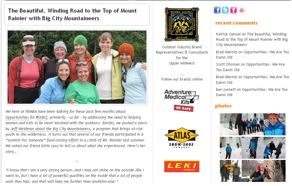
    As I mentioned before, two aspects of my long weekend in Colorado deserve their own posts, and this is the second of the two - my experiences outdoors. Between a 14,265' 14er and beautiful Bear Peak, I got my fill of beautiful mountains and banked a number of important lessons!

    At the trailhead, Alec leading the way.
    Quandary Peak, East Ridge - 14,265'
    Less than 24 hours after I arrived, Alec and I were en route to the East Ridge route up Quandary Peak. Quandary ranks 13th among the 14ers in Colorado at 14,265', and is the tallest peak in the Tenmile Range. The East Ridge trail begins at 10,805' and covers just under 7 miles round trip. The trail head was already 4,000 ' higher than I'd ever been. It was a formidable task for my first full day in the mountains, but I was more than up for the challenge!

    After the two hour drive from Boulder, we arrived to find what seemed like hundreds of cars lining the dirt road and overflowing from the small parking lot. That's the beauty and the curse of being in a place where playing outside is everyone's favorite past time; there'll never be a shortage of company on the easily accessible trails!


    The weather couldn't have been more perfect. From the top, we had clear views of Atlantic Peak and Fletcher Mountain along with a handful of deep blue lakes. The eastern slope still had a bit of snow on it, too! I'm glad it was my first 14er.

    ...the Altitude
    Being at altitude, generally considered over 8,000', affects every person differently. As this article describes, "the concentration of oxygen at sea level is about 21% and the barometric pressure averages 760 mmHg. As altitude increases, the concentration remains the same but the number of oxygen molecules per breath is reduced. At 12,000 feet (3,658 meters) the barometric pressure is only 483 mmHg, so there are roughly 40% fewer oxygen molecules per breath." Acute Mountain Sickness (AMS) can plague even the fittest athletes while some are unaffected, especially when given proper time to acclimatize. Our bodies are remarkably efficient at adapting. We will actually produce more red blood cells to carry oxygen through the blood, and undergo other changes to help adapt.

    I didn't expect to have an easy time with it and tried to stay keenly aware of what my body was telling me. The hardest part was trying to figure out if, at any point, the way I felt actually dangerous because I'd never felt any of the symptoms before. To my surprise, I was completely out of breath no more than ten steps into the hike. It was strange to feel winded without having gone anywhere! My pace was normal at the beginning of the day, but slowed considerably the higher we went.

    All I could think about was how with every step I took, I was up higher than I'd ever been before, and hanging on to that feeling was what got me to the summit. I teared up at one point, thinking about how incredible it was to be so high! By the time the summit came into view, I had started a process where I'd count 30 steps and pausing to catch my breath over and over. I was nauseous at the top, but two and a half hours after starting, I was ecstatic to be standing at 14,265'!

    The descent was downright painful. My feet felt heavy, I was dizzy, and by the time we reached the car at 10,850' I'd developed a migraine. Thankfully, the medicine I typically take for them did the trick. We packed up the car and drove another two hours through Buena Vista and into the San Isabel National Forest to spend the night at 10,000' before planning to attempt Huron (14,003') the next day.

    We set up camp just outside of a the small "ghost town" of Winfield, but by 8pm I decided we needed to head down. I wasn't recovering as quickly as I was comfortable with and as a result of being lackadaisical about sunscreen application, I'd developed a pretty awful sunburn. So we reluctantly packed everything up and drove back to the comfort of 5,400' in Boulder.

    Bear Peak -
    The next morning, I'd recovered enough for a hike, but at lower elevation. Alec chose Bear Peak, which had been among Amy's recommendations for our weekend. Just a mile up the road from Boulder, the trail ascends up a beautiful wooded canyon to the summit. With a little hand over hand scrambling, we made it to a perch that overlooked Boulder to the east and a dark cloud covered Long's Peak to the west.

    This day was a struggle for me as well. Despite having to gain less than 3,000' over the course of the day, the 7-mile hike in long sleeves and pants to protect my sun scorched skin in 90-degree heat really took it out of me. I assumed I was still recovering from the day before as well. But as always, the views from the top made the journey well worth it!

    And the All-Important Lessons

    Build in Time to Acclimatize
    - I went up to 14,265' 24 hours after coming from sea level, which essentially goes against everything I'd learned about preparing for a high altitude climb. I didn't give my body any time to adjust, and paid the price. If we'd done Bear Peak the first day, then driven to the base of Huron to sleep, I might have fared better.

    Don't be Lazy About Sunscreen - Between the excitement and frenzy of packing up to go, I didn't pay nearly enough attention to protecting my skin. It's finally beginning to heal, but I could've avoided all of it with a little more patience.

    Eat and Drink A LOT
    - I thought I did a decent job of drinking enough water and electrolyte-enhanced beverages, but I didn't pay much attention to what I was eating. One of the things Tiffany told me she'd learned was to eat and drink every time you stop, at least every hour. It definitely helps with the last bits of the ascent!

    Climbing at Altitude is Pretty Uncomfortable - I already knew this, but now know first hand exactly what it feels like. That was a big part of the reason for the trip; I wanted to experience the discomfort and learn how to overcome it. It's all just part of the sport. I found that focusing on myself, on each step, and keeping positive thoughts in my head made a huge difference.

    Give Yourself a Break - All of these mistakes aside, this was a learning experience. I went to Colorado to learn. And boy did I. But I'm a perfectionist and don't let myself off the hook easily. After going at what I felt like was a snail's pace, not recovering fast enough, and skipping the second 14er we had planned, I felt like I'd let myself down. I struggled a lot with feelings of inadequacy. But instead of beating myself up about it, I needed to take a step back and realize what I was able to accomplish.

    * * * * *

    As the title of this post suggests, I had an absolutely amazing time exploring Colorado's outdoors, and learned so much over the course of the four days I was there. I love how playing outside is a lifestyle there, and how many people embrace it. I'm depositing the memories and lessons into my memory bank for Rainier, and for the rest of my adventures!

    How Colorado Stole My Heart, Part I - The People

    When I started thinking about how to sum up my long weekend in Colorado, the summary split itself into two parts - the people and the outdoors. I was able to meet and spend time with some amazing folks, all of whom deserve their own post. And my experiences on the trails deserves its own post too, with plenty of room for reflecting on what I learned. So, here's Part I in the two part series about how Colorado Stole My Heart.

    Standing in the doorway to BCM HQ. Photo by Alec Campbell.
    Big City Mountaineers!
    My first stop in Colorado was a place I'd been dreaming about visiting since I signed up to climb Mount Rainier - Big City Mountaineers Headquarters. Friend Alec and I arrived just in time to see a group of enthusiastic young men filling their Jansport backpacks with gear while their guides and mentors looked on. We watched from the doorway of the nearby gear shed, which was full of fun stuff from Keen, Mountain Hardwear, Merrell, and many other sponsoring companies. The basement of the beautiful little house near City Park was as full of gear and clothes, all meticulously sorted, like a little haven for the stuff (gear) dreams are made of.

    Being able to see where the BCM magic happens was inspiring. The organization itself was founded by and is staffed by such passionate, friendly people, especially Brendan Leonard, Hillary Harding, and Elizabeth Williams. The enthusiasm in the office was almost tangible. Photos of past trips, maps, bookshelves full of guides, and BCM flags dotted the walls, all a testament to what BCM can do and has done for under resourced kids.

    As a Summit for Someone climber, there couldn't have been a better way to truly connect with what I've been fund raising for than to meet the people who really make everything happen at their home base. I really began to feel as though the Rainier climb I'm doing in August means something. It's more than just me getting to the top and testing my own limits, it's about others having the chance to test theirs. And I knew all of this, there was just something special about seeing it all happen in front of me. Something really special. It was the perfect start to my Colorado adventure. A big thanks to Brendan and Elizabeth for the tour and the chat!

    BoulderDinnerTweetup
    As it turns out, a lot of really awesome people live in and around Boulder. Big surprise, right? The best part - a bunch of 'em are on Twitter, and we've all been "talking" for months. Any time I have a chance to get face time with people I've "met" on twitter, I have to take it. These friends write blogs, run businesses, go on amazing adventures, kick ass and take names on a daily basis. I couldn't wait.

    We all met for dinner and beer Boulder-style at Southern Sun thanks to Amy's suggestion. And by "we all," I mean Amy, Bracken, Tali, Ben, Erika, and Josh. I spent the night with a giant smile on my face and feeling as though I was being reunited with a group of my best friends I never get to see. It never ceases to amaze me how a group of people who've met on the interwebz, essentially strangers before twitter, are able to converse and meld together so easily.

    The food was pretty darn good too. I've been told I absolutely have to go back and try the tempeh reuben, which I'll add to my mile-long list of reasons to return.

    Photo by Bracken Christensen. From left around the table -
    Josh, Sarah, Tali, Erika, the author, Amy, and Alec.

    New and Old Friends
    ...and Idols
    After a long weekend of hiking, sunburns and altitude sickness, I couldn't wait to visit Pearl Street in Boulder for dinner at The Kitchen. Alec, my host and hiking partner for the weekend, happened to have met one of the women I admire most in the climbing community in his four weeks in town - Majka Burhardt - and worked with her to organize a dinner for all us.

    Friends Alec and Helen, Majka Burhardt and me!
    Majka is an incredibly strong, driven and enthusiastic woman with an anthropology degree from Princeton, an MFA in creative writing, and was among the first five women to earn American Mountain Guide Association certification. I bought and read her first book this past year and have followed her blog since then, admiring her determination and strength through all she's experienced. And earlier this week, this lucky girl got to have dinner with her.

    As I learn and grow as an outdoorswoman, I'm always looking for guidance from other ladies who've accomplished incredible feats and are making big waves in the community I'm excited to be a part of. I'm still fearful, cautious, and very much in need of encouragement when it comes to things I've never done before, like Rainier, and things I have, like rock climbing.

    Majka had words of wisdom about careers, life, and dealing with the altitude sickness symptoms I'd experienced on Quandary Peak a few days before. Her words were comforting and encouraging, spoken with a strength that only comes from knowledge, experience and being a #badassclimbergirl. But, like normal people, we also all spent a while talking about how great the food was, how people living in Denver and Boulder differ, and ganging up on Alec! Although, between Helen, Majka and myself, I think he did pretty well for dinner companions :)


    * * * * *
    I couldn't have asked for a more incredible group of human beings to spend time with this weekend, and look forward to many chances to see them again in the future!