
 ...and so begins another trip report for what I'm hoping is going to be an epic spring and summer! Training for Mount Rainier is forcing me to plan most, if not all weekends around hiking to make sure I'm in good enough shape. It's really a great excuse to focus on getting outside as much as possible! And this weekend was no exception. I had the incredible good fortune of spending it driving to Maryland and Virginia with Dan to climb and hike with George and Aleya!
 Saturday - Climbing and Driving and Camping!
We spent the morning and early afternoon climbing at Earth Treks Rockville. Every time I visit an Earth Treks gym, I'm impressed by the creativity and consistency of the routes. It's obvious they have a group of dedicated setters who are very good at what they do! It doesn't bother me to climb at gyms that rate climbs as easier than they are, (i.e. a 5.8 that feels like a 5.10), mostly because I'm in no position to debate ratings with anyone. But it can be frustrating to climb in a gym that is set inconsistently (i.e. some 5.8 climbs feel like 5.6, others feel like 5.10, etc). I flailed around on a bunch of boulder problems, and sent a V5 before we left for the day. Dan's in the market for a new pair of shoes, and tested out both the La Sportiva Muira VS shoes and the Evolv Optimus Prime, but I think the jury's still out on what his new pair will be!
After a quick stop at Trader Joe's for sustenance, we drove from Maryland down to Shenandoah National Park. Shenandoah and the whole of the Blue Ridge Mountains are just beautiful. All the hills are already covered in green, and with 20 miles to go on Skyline Drive from Thornton Gap to the Big Meadows campground, we had plenty of time to take it all in. One of my favorite things about the park is how accessible it is, how close it is to major cities. A couple of small highways pass right through it! I'm definitely an advocate for truly wild places (Denali), but can appreciate how having a national park so close to major metropolitan areas might expose more people to the beauty of the outdoors.
I
 was surprised to see that the 217-site campground was completely full so early in the season on such a cold night. Climbing Old Rag Mountain. Big Meadows is the closest campground to Old Rag. However, to access popular trails to the top, we had to drive back north along Skyline drive to the Thornton Gap Entrance (20 miles), then south for another 18 miles to the main parking area (via Rte 211, 522, 231, and others). It was certainly the easiest and most viable option for us, seeing as we didn't make it to the park until close to nightfall. But for those with more time, I'd suggest making use of the National Park Service backcountry permits, which allow you to camp near the base of Old Rag. The summit can also be reached from MP 43 on Skyline Drive via the Old Rag Fire Road.
Sunday - Summit of Old Rag Mountain (3,291')
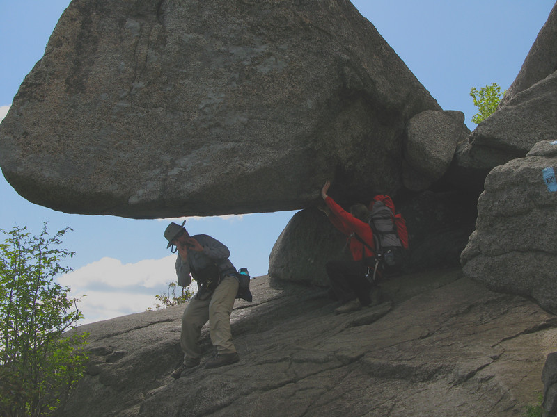
 After an early-for-us (6am) wake-up call, we were at the Old Rag parking area and on the trail. The temperature reached 37ºF by the time we started hiking, which explains why we'd been shivering all morning! An early start is definitely a must for Old Rag due to the trail's popularity; parts of the route can get pretty crowded. Aleya and I both put packs on to add to the difficulty of the hike - it was a perfect Rainier training opportunity!
We followed the Ridge Trail, which starts at the upper Old Rag parking lot and winds toward the summit at a steady incline. The trail is well used, relatively wide and easily passable. But it certainly seemed to be the steeper, rockier, and longer of the two routes to the summit. The NPS trail brochure describes the Ridge Trail route as "a very challenging hike and rock scramble...," and they aren't kidding! As we neared the top, the trail vanished and light blue blazes appeared painted on large boulders, through small canyons, up slabs, and around corners. George had hiked the trail before, and mentioned places where we'd wish we had a rope! I had to take my 30 pound pack off twice when the trail required ascending a large boulder or two and squeezing through a small canyon.
But the 1-mile scramble to the summit was by far the most exciting part, and absolutely worth it; the views at the top were absolutely spectacular. We rock-hopped for a little while, took photos, then picked a spot for lunch. We opted for the longer, but less technical (read: slightly boring but still pretty!) Weakley Hollow Fire Road for the route down. According to Dan's Garmin, the entire trip was 10 miles, included 2600'+ of elevation gain, and took us six hours.
The Mornings After
I'm always sad to come home after trips like that, but the soreness in my calves and hips serves as a constant reminder of how great the weekend was! I'm so lucky to have met people like Aleya and George, and look forward to our next adventure.
